State Route 37
MTC and its partners are working to make state Route 37 more resilient against chronic traffic congestion, flooding and sea level rise, in order to preserve vital connections between jobs and homes.
- Westbound SR-37 will be fully closed from State Route 29 (Vallejo) to State Route 121 (Sonoma): Friday, April 19 at 9 p.m. through Monday, April 22 at 4 a.m. and on Friday, April 26 at 9 p.m. through Monday, April 29 at 4 a.m.
- Eastbound SR-37 will be fully closed from State Route 121 (Sonoma) to State Route 29 (Vallejo): Friday, May 3 from 9 p.m. to Monday, May 6 at 4 a.m. and Friday, May 10 at 9 p.m. through Monday, May 13 at 4 a.m.
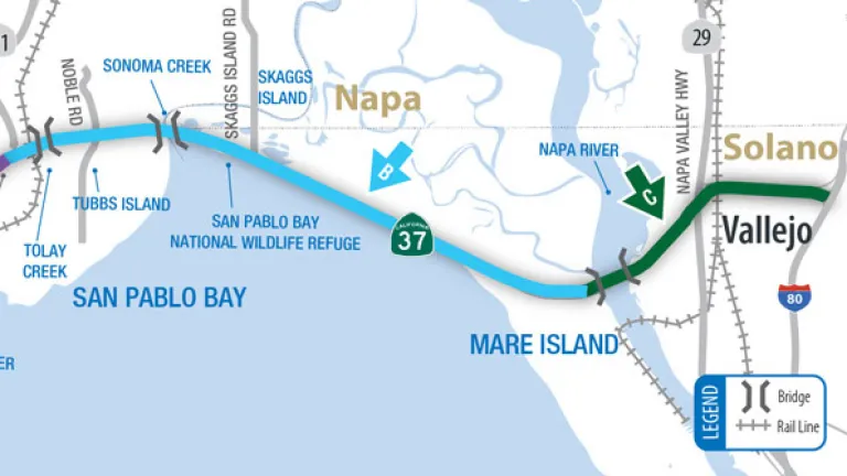
State Route 37 (SR 37) runs along the northern shore of San Pablo Bay, linking US 101 in Novato with Interstate 80 in Vallejo. This 21-mile corridor connects Solano County cities and some of the most affordable housing in the Bay Area with jobs in Napa, Marin and Sonoma counties. It also serves as a vital connection between Marin, Sonoma, Solano and Contra Costa and the Central Valley.
The low-lying corridor experiences a number of challenges, including chronic traffic congestion, vulnerability to flooding that will increase with sea level rise, and potential impacts on highly sensitive wetlands.
Making SR 37 More Resilient
MTC and its partners are working on the development of corridor improvements to make this critical regional transportation corridor higher, safer, greener and built to last.
Near-term flood reductions include:
- Raised pavement elevation
- Flood walls, drainage, culverts and slide gates
- Bladders and portable pumps
Interim solutions to:
- Improve traffic flow and peak travel times
- Provide equitable transportation for underserved communities
- Include a high-occupancy vehicle (HOV) lane and encourage public transit
Ultimate improvements will:
- Adapt SR 37 to sea level rise
- Create ecological resilience in the surrounding environment
- Enhance public access
- Provide safe mobility for bicycles and pedestrians
See what MTC and its partners are planning for SR 37. Participate in meetings and events to share your views.

Caltrans’ SR 37 project maps, background, meetings and more.

The Resilient SR-37 Partnership agencies include:
- MTC
- The California Department of Transportation
- The Transportation Authority of Marin
- Napa Valley Transportation Authority
- Solano Transportation Authority
- Sonoma County Transportation Authority
- Sonoma Marin Area Rail Transit District (SMART)
The Partnership agencies work closely with colleagues from:
- U.S. Army Corps of Engineers
- U.S. Fish and Wildlife Service
- U.S. Environmental Protection Agency
- National Oceanic and Atmospheric Administration
- California Natural Resource Agency
- California Department of Fish and Wildlife
- San Francisco Bay Regional Water Quality Board
- San Francisco Bay Conservation and Development Commission
- Federated Indians of Graton Rancheria
- Yocha Dehe Wintun Nation
April 24, 2023 Meeting
- The latest project updates were presented
View the 4/24/23 video and meeting materials
September 14, 2022 Meeting
- Caltrans shared the results of its evaluation of alternatives for the future of Highway 37
Watch the 9/14/22 video
February 2, 2022 Meeting
- SR 37 Sears Point to Mare Island Improvement Project
Watch the 2/2/22 video
