Map 14 — Point San Pablo Peninsula to Point Pinole Regional Shoreline
Richmond
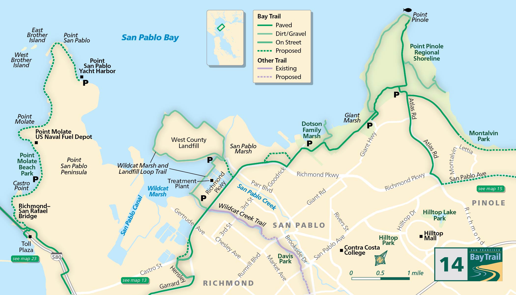
Still a work in progress, the Point San Pablo Peninsula will someday feature a shoreline trail along the edge of this scenic peninsula to the remote Point San Pablo Yacht Harbor.
A barrier-separated path on the Richmond-San San Rafael Bridge is in place for a four-year test period. Don’t miss this unique perspective as you traverse the northern part of the San Francisco Bay.
Plans are in the works for a new trail that will lead you to Point Molate Beach Park where you will be rewarded with views of the bridge and Mt. Tamalpais. Existing Bay Trail along the Richmond Parkway connects to the Wildcat Creek Trail.
Wildcat Marsh and Landfill Loop Trail
To get closer to the shoreline, follow the creek trail toward the bay. From the observation platform overlooking Wildcat Marsh, you can see a living wetland in the midst of a heavily industrialized landscape.
Along Wildcat Creek east of Richmond Parkway, the first phases of the trail are in place with plans to extend from the observation platform atop the berm overlooking Wildcat Marsh all the way up to Wildcat Canyon in the East Bay hills. From the platform, you’ll notice the Chevron refinery to the southwest. Continue north along the Bay Trail to the West County Wastewater District’s treatment plant along the Wildcat Marsh and Landfill Loop Trail.
This trail includes a 2.8-mile loop trail that circles a closed landfill with amazing views of Mt. Tamalpais, shorebirds and other waterfowl in San Pablo Marsh and Wildcat Marsh.
Point Pinole Regional Shoreline
Explore the Upper Trail for an elevated view of the marshes. Plans are in the works to connect the landfill loop trail to Dotson Family Marsh and Point Pinole Regional Shoreline, but they are not linked at this time. Access Point Pinole Regional Shoreline from staging areas off Atlas Road, Giant Highway or at Dotson Family Marsh.
The sweeping grasslands and stately eucalyptus groves of Point Pinole Regional Shoreline would be spectacular anywhere in the Bay Area. But along this stretch of industrial bayshore, the tranquility and recreation opportunities of this park are especially welcome.
This is one of the largest waterfront parks in the entire Bay Area, with some 2,315 acres on the Point Pinole Peninsula and adjacent marshlands.
Point Pinole Fishing Pier (Richmond)
This 1,250-foot pier is extremely popular and takes the adventurous angler into the deeper waters of San Pablo Bay. Kingfish, perch, smelt, flounder, sole, sharks, skates and rays are common; salmon, steelhead, striped bass and sturgeon have been caught, too. The pier boasts panoramic views of San Pablo Bay and Mt. Tamalpais.
Point Pinole Regional Shoreline (Richmond)
This huge 2,315 acre park is the former site of a dynamite plant. With over 12 miles of trails, several picnic areas with BBQs, a play area, volleyball court, horseshoe court, a popular 1,250-foot fishing pier and amazing views of Mt. Tamalpais and San Pablo Bay, there’s something for everyone here.