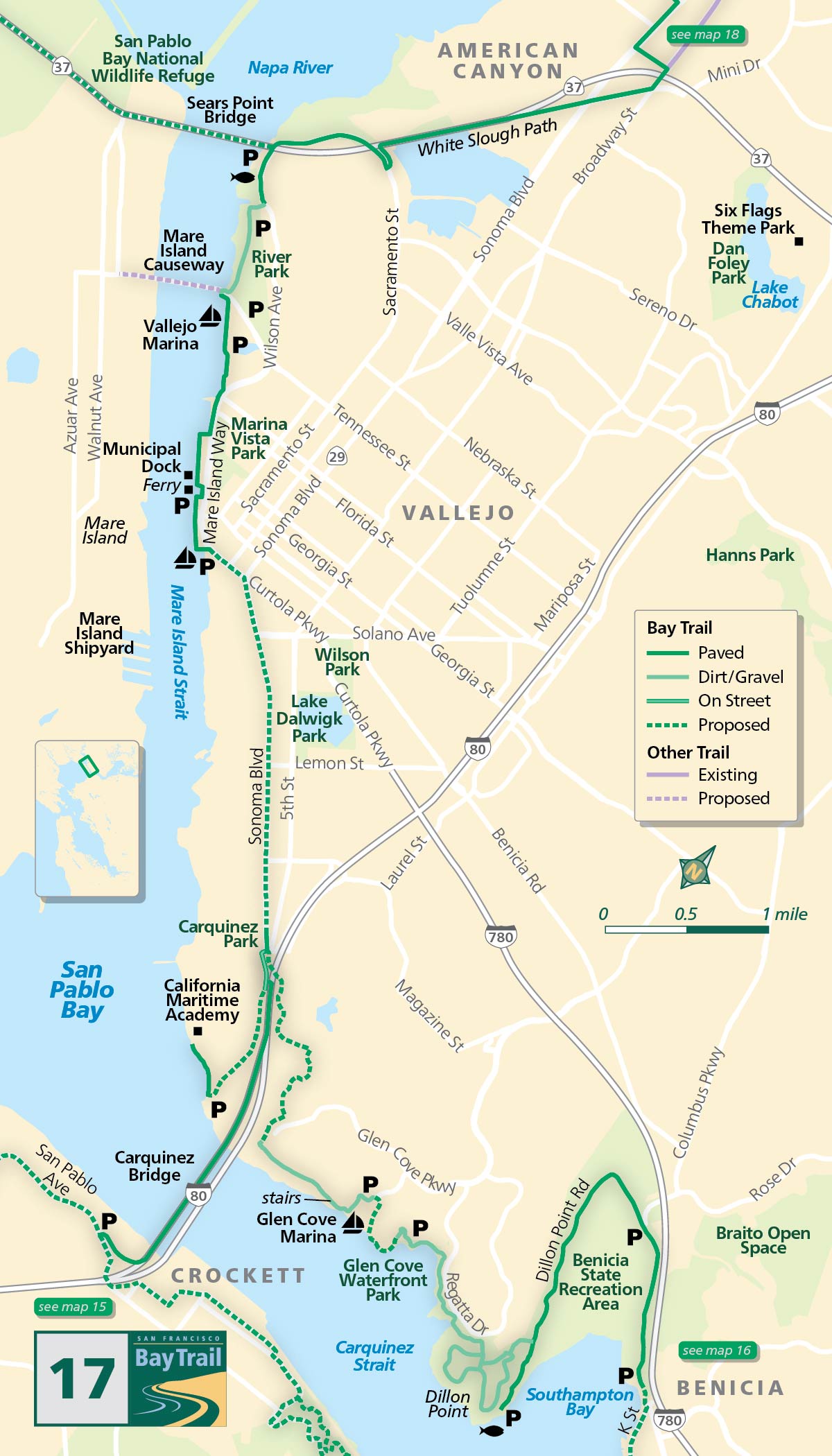
Map 17 — Benicia State Recreation Area to White Slough Path
Benicia
A walk through the Benicia State Recreation Area offers a sense of the shoreline as it was in the time of the Karkin people.
Open space and natural rhythms prevail here. A paved trail leaves the eastern parking lot (off Military West) then turns into a paved trail/road at the main entrance (fee). From here you can hike, ride, or drive to the Dillon Point parking lot. To reach the point — an especially good fishing area for sturgeon, striped bass, king salmon and flounder — walk down to the shoreline from the parking lot and follow the gravel trail for a quarter-mile.
About half a mile before you arrive at the Dillon Point parking lot, the Bay Trail route veers west on a dirt trail and leads to Glen Cove Waterfront Park, a tranquil shoreline retreat featuring both Bay and Ridge Trail segments as well as significant Native American history.
A gap in the Bay Trail between Glen Cove Waterfront Park and Glen Cove Marina currently requires an on-street work-around. From the Park, use Whitesides, South Regatta, Glen Cove Parkway and Glen Cove Marina Road to access the Marina.
Amazing views of the Carquinez Straight, the Carquinez Bridge and the C&H Sugar facility can be had from the bluff-top Bay Trail heading west from Glen Cove Marina. This segment is a natural surface trail with stairs and is not recommended for road cyclists.
Carquinez Bridge
To reach the Carquinez Bridge and points west via road bike, use city streets. On the west side of the bridge is the California Maritime Academy, where officers are trained for duty on U.S. merchant ships. The academy’s 7,000-ton training ship, the Golden Bear, is occasionally open for group tours (contact the Academy for tour info).
Vallejo
Heading up the Mare Island Strait is where you’ll find Vallejo’s active waterfront, with two miles of spectacular shoreline Bay Trail and a view of the former Mare Island Shipyard across the channel.
To reach the White Slough Path, continue on Wilson Avenue (no bike lanes or sidewalks) when the pathway ends. Curve under the Highway 37 freeway and over to Sacramento Street where the White Slough segment begins.
White Slough (Vallejo)
Mudflats reclaimed by nature now host hundreds of waterfowl, raptors, shorebirds and gulls. Black Rail are known to breed here, and likely Ridgeway’s Rail too. The Saltmarsh Common Yellowthroat also breeds here, as do Least Terns. All seasons have good birding potential.
Al Zampa/Carquinez Bridge (Vallejo, Crockett)
There is a two-way 12-foot-wide bicycle and pedestrian path on the west side of the western (westbound) span. The distance is 0.6 miles.
River Park (Vallejo)
This bit of green in the midst of urban Vallejo offers great views of the former Mare Island Naval Shipyard. A paved segment of Bay Trail runs along Wilson Avenue on its east side and natural surface trails run along the shoreline of Mare Island Strait.
Vallejo Promenade
An approximately 1.4-mile walk (each way) from River Park off Wilson Avenue to Independence Park off Mare Island Way. This flat shoreline walk offers great views of Mare Island, the former Naval Shipyard, and passes by the Vallejo Ferry terminal. Trail surface is both paved and natural.